


Kitling Peak (8,003ft) and Graybeard Peak (7,965ft)

The view from easy pass looking towards Mt Logan
Sept 6, 2021, 8:45am – 5:45pm
13 miles, 5,100ft gain
I had Monday free for a day trip and chose a few top 200 peaks that would be a reasonable drive away. Kitling and Graybeard are near easy pass and both sounded like fun scrambles. Importantly, since I had to drive up from Seattle in the morning, the trailhead is only 3 hours away, making these some of the closest top 200 peaks I have left to Seattle.
I’d read Eric Eames scrambled these peaks as a day trip in 7.5 hours in June, so I hoped to squeeze them in a similar time. Though his conditions were much snowier. I’m still probably not at full strength after Pik Pobeda, so decided not to do the more ambitious day of tagging on Arriva and Fisher Peak. Those will have to wait for another trip.
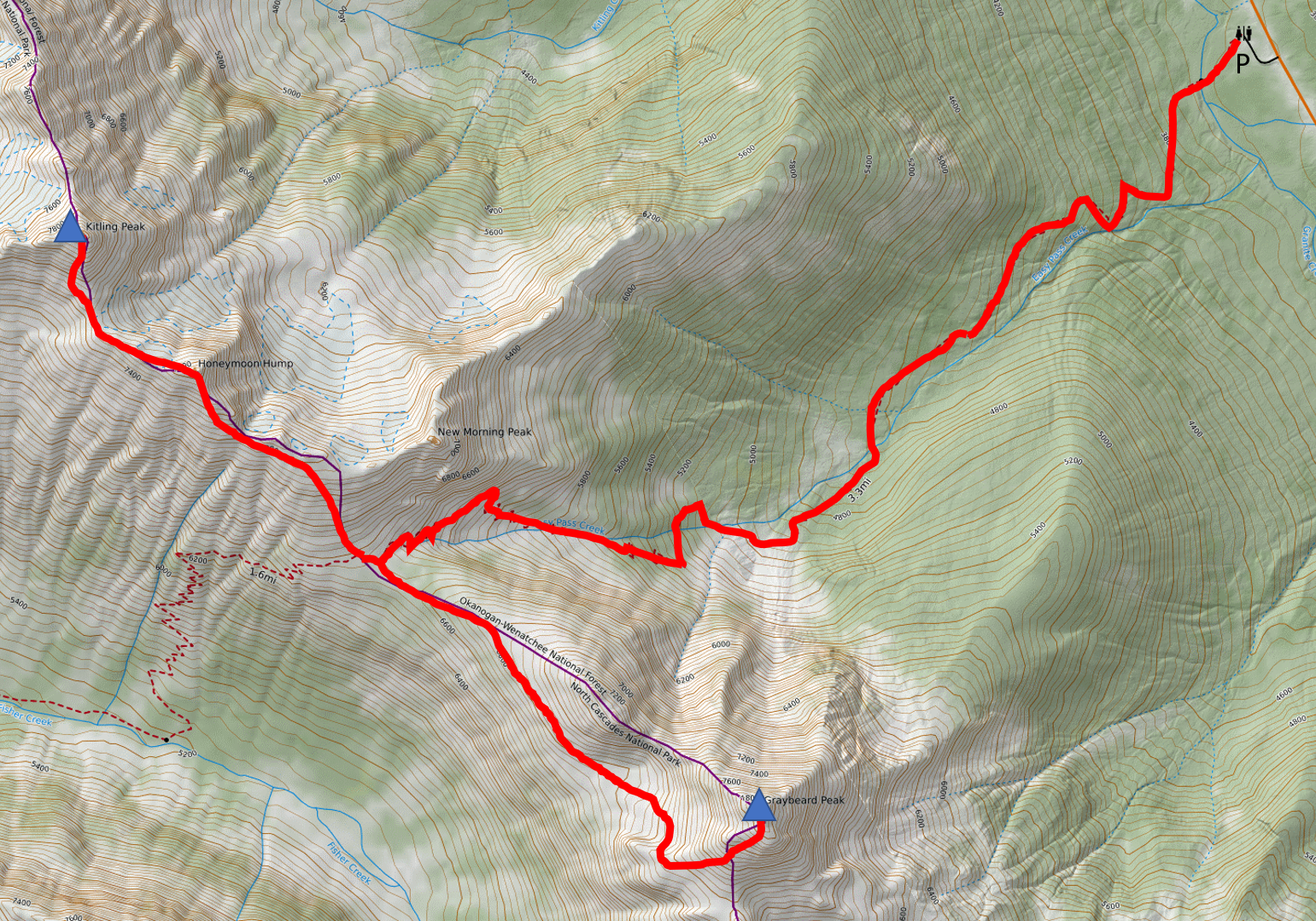
The route
For Graybeard the standard route is to traverse the southwest face at 6800ft and then ascend a 4th class gully to the summit. But Ken Jones reported a 3rd class route via the southwest ridge. I was in the mood to keep the whole day 3rd class or lower, so decided to try Ken Jones’s route on Graybeard first, then tag the easier peak Kitling second.
I left town 5:30am Monday morning and was hiking from a very full Easy Pass trailhead by 8:45am. I’ve only ever been on this trail in the dark (when I did ragged ridge peaks + logan in two days in 2018) and it is actually very scenic in the light. The leaves were starting to change colors in the open avy paths in the valley, and blueberries were plentiful. I made it up to the pass in about 1.5 hours and turned left, following a climbers trail through the larches up the northwest ridge of Graybeard.

The traverse to Graybeard
The path petered out at the edge of treeline around 6,800ft, and I started traversing there. The terrain was mostly easy going and open, though some slopes involved steep loose sidehilling on dirt and scree. I dropped a small ways down to the basin below the summit, then scrambled up fun 3rd class rock to the southwest ridge. I then wrapped around the summit to the southwest slope and started up talus and scree.
Higher up I found some more solid rock to scramble, and eventually made it to the south summit. I saw what were either crampon or hiking pole scratches on rocks there, so figured other climbers had taken this route at some point. I ditched my poles there and started my way toward the true summit.

Looking down Fisher Creek from the Graybeard summit
I looked around for a while but couldn’t find any easy 3rd class route down to the notch between the summits. Everything was loose and exposed. Eventually I downclimbed back a bit along the ridge and traversed on a sloping ledge below the false summit directly to the notch. I would call this class 4, though just for a short section. (I still think this route is safer than going directly up the 4th class gully, which is in the line of fire of lots of rockfall). From there I made some more class 4 moves out of the notch, and then it was easy scrambling on loose rock along the ridge to the summit.
There was a cairn, great views, but unfortunately no summit register. I’ll have to start bringing my own to place on these lesser-traveled peaks. I was impressed by the view over to Mt Logan. The Douglass Glacier was much smaller than I thought it would be. I’d skied the Douglass with Ryan back in March and thought it extended very far, but now that snow has melted down I can tell we were mostly skiing on deep snow above rock slabs, not on glacier.

Looking down at Easy Pass
I soon carefully scrambled back to my poles at the south summit, then scree surfed to the basin and traversed back to Easy Pass. There were a few hikers heading down and I took a short break to admire the view. From the pass I ascended steep grassy slopes on the north side, then traversed just below some pinnacles on the southwest scree slopes. After the pinnacles I scrambled directly up to Honeymoon Hump, passing two other hikers coming down from Kitling.
I followed the ridge northwest from the summit to the col below Kitling, then traversed a bit around the south ridge to an easy scree and tree gully. I followed the gully up and right to regain the south ridge, then scrambled the fun 3rd class ridge to the summit. This time I was treated to views of the Mesahchie and Katsuk Glaciers, which I had never seen from this angle. I hear they make fun backcountry skiing objectives in the spring. Unfortunately there was again no summit register.

The view from Kitling
I hung out for a while on Kitling, reasoning if I got back to the car too soon I’d get stuck in holiday traffic driving home. I was hoping to get home late after everything cleared out. Eventually I headed back, this time traversing loose scree slopes around Honeymoon Hump. I had a mellow hike back to from Easy Pass and got back to the car around 5:45pm, late enough for a traffic-free drive home.


© 2021, egilbert@alum.mit.edu. All rights reserved.
You must be logged in to post a comment.